Friday 29 June 2012

The Giant's Grave Co Dublin


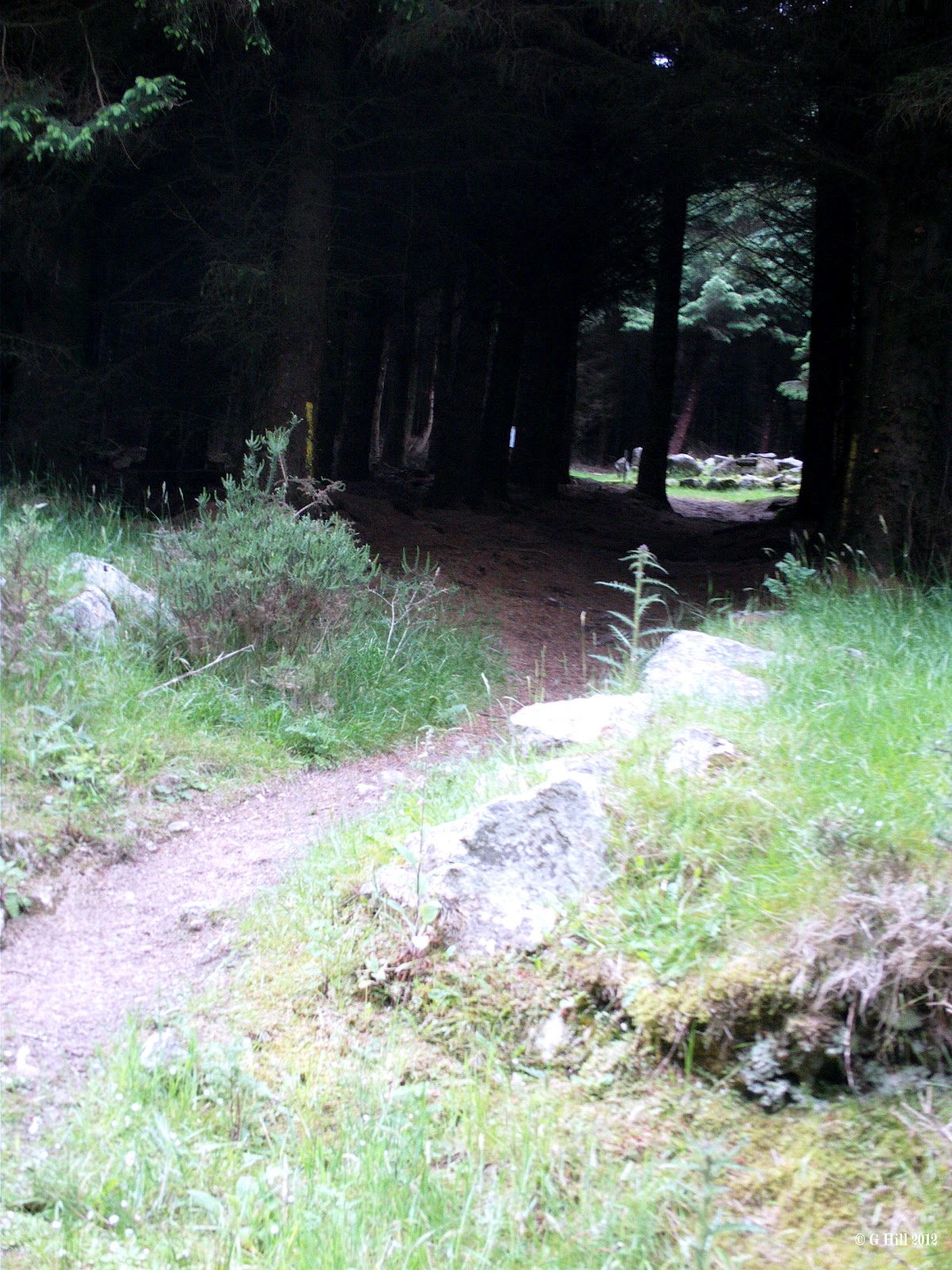
                                            Above Image: The Forest Trail
                                   Below Image: The Track leading to the Site


                         Above Image: Cairn Stones mixed with Standing Stones


                                       Above Image: The exposed chamber


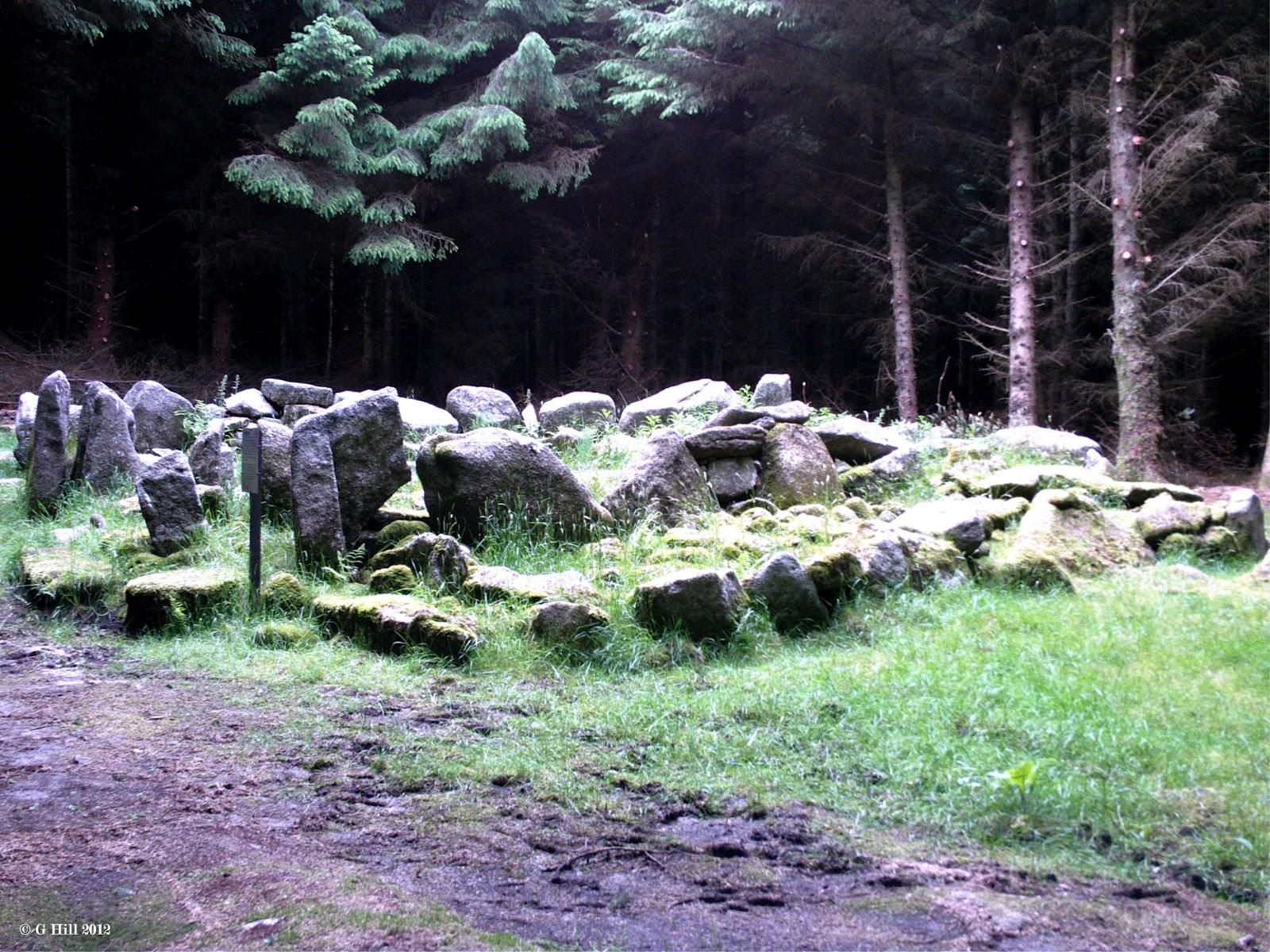
This Neolithic Wedge Tomb is really an incredible sight. Photos just dont give it justice. It needs to be seen in person. It is a rectangular chamber positioned into a wedge shape which had a Cairn constructed upon it. Experts have dated it to the Bronze Age circa 1700BC. It was excavated in 1945 and within they discovered some cremated remains, flint implements and some pottery. The Cairn at one time stood almost two metres high but has now fallen into ruin with the roof of the chamber now missing. Some of the Cairn stones are still scattered among the surrounding standing stones.
The Tomb is known locally as "The Giant's Grave" and is situated in a circular clearing in a pine forest on the lower East slopes of Two rock Mountain. This treasure is hidden away but is so easily accessible on foot that it is incredible that it is not visited more often. Maybe in some ways that is a good thing as it's almost secret spot is devoid of any litter and such that plagues some of the other historical sites that we have visited.
The site is reached by way of a walking trail from a gate on Ballyedmonduff  Road. A sign posted by the gate thanks two local landowners for their co-operation in allowing access across their land.
A short walk across a sheep filled field leads you to a boundary fence with a sturdy ladder type metal stile that is easy to climb and drops you right on the forest trail.
Once over the stile we followed the trail to the left. The trail bypasses a Golf course on it's left and then it bends sharply to the right. It took less than ten minutes to reach this point. Just after the bend and a few yards later on to your right hand side is a small track leading off the trail into the forest. Even from this position we could see the Tomb between the tall trees. The track led us across a narrow gurgling stream with a couple of stepping stones to aid progress and then a few yards later we entered the clearing. On first view this ancient Tomb is truly an amazing sight. The trees had been felled around the perimeter making the glade an almost perfect circle.
Although quite ruinous now the Tomb still looks impressive. We have come across several Cairns & Tombs in the past but this is by far the largest and most interesting. Some of ths standing stones still remain on the North And West sides and it also surprising to see an information board posted nearby.
I have to say we spent a good deal of time here. There was a distinct atmosphere about the place. A real sense of history. To be honest we left the site a little awe-struck.
As with most of our Castle ruin trips, we were the only ones present when we made the visit on a fine June evening. In fact we met only two other people who were out running on the forest trail. We will definitely return to this site in the future.
The easiest route to find the Tomb is as follows: From Kilternan on the R117 towards Enniskerry take a right hand turn at the blue wooden Church onto Ballybetagh Road. Follow this Road around two sharp left bends and about 600 metres along you will reach a fork in the road. Take the right hand fork signposted for Glencullen. After you have passed Johnnie Foxes Pub you will come to a crossroads. Turn right. Drive for about 1.5KM passing Glencullen Golf Course on your left. This is Ballyedmonduff Road. Look out on your left for a Bungalow with a cylindrical bay window and a wire fence posted atop a stone wall. Just a little along this fence you will find a stepped back gate with a track leading up to the forest. There is a small wooden pedestrian gate to the left of the main gate for safe access. We parked to the side of the road just past the gate where it was slightly wider but in general it seems there are few other spots to park.

Sunday 24 June 2012

Whitechurch Old Church Co Dublin

                          Above Image: The Entrance gate (locked) on a leafy lane


                                           Above Image: The central arch


                                  Above Image; Some of the needless daubing


The ruins of the old Whitechurch Parish Church stand on slightly elevated ground overlooking the Whitechurch stream and must have been very picturesque in it's time. They are now unfortunately three quarters surrounded by a modern housing estate. The parish dates back to the 12th century when it was under the auspices of St Mary's Abbey. There is not much information regarding it's history thereafter other than it was a functioning Parish Church and was out of use by the time that the new Church was built nearby in 1827. The graveyard surrounding the ruins is believed to be circa 1720AD.
The Church consists of two chambers although it may have originally been only one as was the norm for these type of  structures with the additional chamber added later. The three main gables still stand and form a dramatic looking ruin, but most of the side walls have crumbled away over time. There is a granite entrance arch and a rectangular opening in the East gable. The central gable has a small connecting archway.
Access to the ruins is by way of an arched gate on it's South East side which is approachable on foot from Whitechurch Road  up a narrow lane way.  Unfortunately the gate remains padlocked, no doubt by the local council to deter any antisocial behaviour within the grounds. Indeed parts of the ruins have already been carelessly daubed with graffiti. Looking through the gate you have a view of a large monumental cross and the Eastern facing end of the Church. There are steps that lead up the incline to the ruins that are now overgrown, the grass standing almost hip high in the graveyard enclosure.
Not to be deterred from getting a closer view, we drove around into Grangebrook estate where a cul-de-sac circle provided a parking space for our car. There is an area of grass here sloping down to the stream and a trail can be made through the grass. While walking through this grass on the evening that we visited, a fox darted out past us and ran into an adjacent clump!.
The wall of the graveyard is high enough but we quickly managed to find a spot where it was just about possible to clamber up and over and finally gain access!
Within the ruins are what appear to be two early Christian burial stones affixed to the East gable. There is some interesting stonework and the West Gable sports two splayed windows. The Church seems somewhat neglected being quite overgrown in places and it appears that the long grass is doing it's job in deterring any further vandalism as it's not a place you could comfortably sit down in. It is a pity though that a few careless individuals can cause this interesting ruin from being restored to a more picturesque state.
To find the Church ruins, take the R115  south from Rathfarnham (Willbrook Road) When you reach the fork in the road at the old Tuning Fork Pub, take the left hand route. Continue on straight through the crossroads with Taylor's Lane and at the following roundabout turn left. Take the first turn right into Grangebrook estate and then almost immediately the first left. You can park at the end of this road for a short time without blocking any entrance ways and you will see the ruins on your right.

Thursday 21 June 2012

The Grey Abbey Co Kildare


                                    Above Image: View from the boardwalk


                                      Above Image: The terrible state of things


The Grey Abbey (named after the colour of it's Monk's habits) was founded for the Franciscans by William De Vesci around 1254AD. Under the Fitzgeralds it remained an important site until it became part of the dissolution of Abbeys in 1539. It is Known that several Earls of Kildare are interred on these grounds.
The Abbey is in a very sad state at the moment. The walls appear  in places to be close to collapse and are propped up by wooden buttresses and timber supports. The East gable is still standing but the other walls have suffered badly. The ruin is overgrown quite a bit and all in all is looking decrepit. I always find it a shame that sites like these are not cared for more and kept in as good a shape as possible as they are part of the rich historical heritage of this country.
The ruins lie just South of Kildare Town on the Grey Abbey Road. As they are situated within a walled graveyard, you will need to enter by way of a stile in the wall or the gate (if open). The first thing you will meet is a lot of wire fencing around the ruins and a large sign saying "Danger Keep Out" This is not here for no reason as explained the ruins are in a bad state. Someone it seems has trampled down part of the wire on the North facing side allowing access to the interior. As there is no roof to collapse in and a fairly wide gap in the wall we took a chance and had a quick look inside. The ground is uneven and overgrown but we did not get too close to the actual walls.
I would in hindsight not recommend crossing the beaten down fence as having done so on impulse I can see how dangerous a condition these ruins are in, but I felt in this instance the opportunity was afforded to make some record of the site  before it degenerates further. The ruins are bordered on the Southern side by a boardwalk from the Kildare Shopping Outlet and safely give a good if not slightly distant view.
To find The Grey Abbey, take the M7 Motorway from Dublin and take the junction 13 exit. Turn left at the roundabout at the top of the exit ramp onto the R415. A few yards later take the first left turn onto Grey Abbey Road. Drive for about 700 yards and you will see the ruins to your left. Parking is limited on the road but we parked conveniently in the car park of the supermarket opposite the graveyard.


SECOND VISIT APRIL 2016


                              Above & Below Images: The all new brighter version!


Took a second visit here to the Grey Abbey and things have really changed in the four years that have passed since I first visited here. The Abbey has been completely cleared of overgrowth and allows the ruins to breathe again. Features such as arched windows can now be discerned more clearly. A smaller more practical wooden fence surrounds it and still contain the alarming "Danger Keep Out" signs. Yet there is still a break in the fence on the North side which allows you to wander in around the ruins. Really worth a visit now, just follow the directions as above.  Many thanks to John Shortland for putting me wise to the renovation.

Tuesday 12 June 2012

Ballyboggan Abbey Co Meath


Located about 400 feet from the roadside, in a field behind a wall enclosed graveyard, lie the angular ruins of the Abbey of De Laude Dei at Ballyboggan. This building is one of the least known of the Augustinian Abbeys in Ireland and was first constructed in the 12th century. It was in it's time a popular place of pilgrimage but unfortunately was gutted by fire in 1146 and had to be rebuilt. It suffered again under Henry VIII's suppression of Abbeys and was dissolved in 1538, the lands then given over to the De Berminghams.
The abbey would seem to be constructed in two parts. The eastern facing section has a large arched window in it's gable end while the Western section is now but two long walls. There does appear in this section to be some evidence of a now disappeared large window. The sections are divided by a medium height boundary wall which although has wire fencing running along the top can be traversed at a couple of points.
There are a lot of historical sites in and around Edenderry and we found this Abbey while looking at some De Bermingham Castles nearby. A roadside gate leads up a long lane way adjacent to a graveyard. This brings you directly to the site. The ruins are extensive enough and look quite striking on first view. The eastern section has an entry door and this part is the more complete.Within there is some interesting stonework to be viewed. The other section seems quite divorced as the walls between may have been removed or indeed collapsed over time. The whole layout left today appears quite strange. What does remain are parts of the Nave, the Chancel and the South Transept. The field in which the ruins sit appear to be grazing land (as Cows are present) but there are no prohibitive signs so you can visit both sections easily. One thing though, you will have to hop over  the boundary wall and the ground on that side of the approach to the Western section can be quite spongy and at times muddy so be prepared. Best advice is not to visit on a day when rain is present or just recently fallen.
To find Ballyboggan, take the R401 road from Edenderry toward Kinnegad and drive for about 2 miles.You will pass Carrick Castle (see earlier post here) on your right and about another 2 miles on you will spot the ruins of the Abbey in a meadow on your left hand side. Look for the graveyard entrance gate. There is just about enough room to park at the gate  but it is on a sharp bend and cars tend to come around this bend at speed, so it is advisable to park a little way up the road on the straight.

Tuesday 5 June 2012

King John's Castle Co Louth


                                       Above 2 Images: Some interior views


                                          Above Image: The access steps


In 1210AD King John of England is said to have made a three day stay at Carlingford  The Castle he stayed in had been commissioned by Hugh De Lacy in the 1180's and it subsequently became known as King John's Castle. The Castle was constructed in two parts. The original De Lacy section forms the Western part and the eastern section was added in 1261. Further alterations took place in the 15th and 16th centuries.
The Castle stands strategically on a rocky outcrop overlooking Carlingford Lough with the majestic Slieve Foy mountain as a backdrop. It stood on the frontier of The Pale and so was in a very defensive position. The town of Carlingford grew healthily in subsequent years in the shadow of the Castle. Carlingford is derived from the Viking Kerlingfjoror which loosely translates as "Narrow Bay of the Hags"
The Castle consisted of two storeys and a basement. The great hall overlooked the lough while the living quarters were situated to the rear. The Castle had several owners over the years and history records that it was laid siege to unsuccessfully by Hugh O'Neill in 1596 and was fired upon by Jacobite's in 1689. It also served some time as a hospital prior to the battle of the Boyne The history becomes more sketchy from there on but records state that some repairs were made by Lord Anglesey in the late 1700's. Following that it appears to have just fallen into ruin.
We have wanted to visit this Castle for some time but were always deterred by reports that it was closed to the Public for safety reasons. Apparently the masonry within is quite brittle and the former basement is filled with it. There are ongoing efforts to shore it up so that it can eventually be reopened. Nonetheless, this ruin is well worth a visit and we were glad that we did in the end. Even though the interior is out of bounds you can still ascend the stone steps from the pier and walk completely around the base of this great ruin high on it's craggy rock. Rails have been added for safety on the lough side of the walkway and the views from this aspect are breathtaking especially on a clear sunny day. The Castle is joined to the Town by a large arched bridge that crosses the road that you arrive on and this makes your first sight of this ruin all the more impressive. The best approach for access is from the pier as the gate on the Town side remains locked.
To find King John's Castle, take the M1 motorway from Dublin to Dundalk and exit for the N52 Dundalk North. Follow the signs for the R173 road to Carlingford .It is about a 20 minute drive and you can park your car on the pier for easy access.